Design Thinking
If you would like to talk about your project call (02) 4474 5861
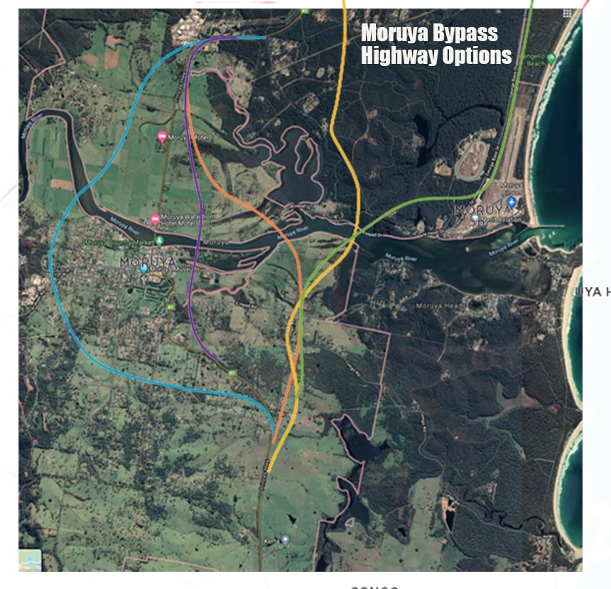
Moruya Bypass Poll – Which option do you prefer?
At the moment the orange path has been selected as the preferred option. But would like to hear your thoughts and preferred option below.
You can also leave a comment at the bottom of the page.
Use the below poll below to see the results of which option is preferred for the new Moruya bypass. All you have to do is select an option and click submit, nothing else.
If interested, here is a link to the Moruya bypassStrategic Corridor Options Report
Poll has ended
The poll has been switched off now as there was some very odd behaviour towards the yellow option (roughly 200 votes in a short period of time) which needs to be investigated more.
Other than that please view the results with a grain of salt but it does give some insights into preferred options and there is good commentary below too.
Moruya Bypass and Moruya Bypass
46 thoughts on “Moruya Bypass Poll – Which option do you prefer?”
Write a Reply or Comment
This Article is From:
Design ThinkingLast updated on
Recent Articles from Design Thinking
- Moruya Bypass Poll – Which option do you prefer?
- Clear Definition of an SEO Keyword Strategy
- SurfEars 3.0 Review
Design Thinking Sections
- Business Tools
- Design Process
- Designers Bookshelf
- Ecommerce – Shopping Carts
- Explaining Technical Jargon
- Industry Leaders Say
- Interesting & Creative
- Marketing Fundamentals
- Online Video Tutorials
- Professional Development
- SEO – Search Engine Optimisation
- Social Media
- Typography & Fonts
- UX Design & App Development
- Web Accessibility
- Web Design & Development
- WordPress – Custom Themes & Development


Instinctively creative & thoughtful strategies with result orientated outcomes
Visually communicating effectively with your potential & current customers adds to the good business experience.
BJ2DESIGN combines a wealth of design knowledge with creative business strategies to create result oriented work.

Proof I would need to see the proof. I like nether options, would prefer the by pass come off the Clyde above Neligan Bridge, behind Mogo, behind Moruya behind,Bodalla and Narooma. This would form a fire break and it could still divert the traffic away from the residential area and not be an eyesore in your face ever where you turned
Totally agree
Now that’s an option I havent considered, but you are right, it would solve the problem at mogo. Narooma will be a problem so perhaps going over the mountains is the answer.
Yellows the most direct route off the Princes hwy
Certainly is, and has the least impact on residents. It also requires less construction than building an elevated road across the floodplain.
I agree, and it bypasses the Industrial park also.
Agree, however heavy vehicles stopping at the Moruya Industrial area, then continuing South will have to still go through Moruya. We want to get the heavy vehicles out of the Moruya main street.
Is there any difference in costings?
There is a full report here and yes costing varies from one option to the other: https://roads-waterways.transport.nsw.gov.au/projects/01documents/moruya-bypass/moruya-bypass-strategic-corridor-options-report.pdf
The orange option makes most sense but the residents of Noads road will be impacted severely and I worry for there mental health. I have friends that live there and they are struggling with the uncertainty.
Purple
I think purple will be better for business less cost will protect our beautiful out look along the river we need to protect our point of difference to attract tourists.Are we retaining our original bridge ? Where do we interact with bypass ,How does hospital interact with airport.Why do we need to impact so many homes and agricultural businesses so many unanswered questions
Yes I agree with you Geraldine, so many unanswered questions.
Needs to go where there is the least impact to people, businesses and environment.
Not happy with the way transport NSW have handled the whole process.
yellow or Orange. purple far to close to town with noise!
Needs to link to highway and George Bass snd airport otherwise those living on the coast road (large amount of population and ambulance) will be disadvantaged and will have to go through Moruya to access the hospital.
Valid points danielle.
Definitely orange. Purple is too close to town. It makes sense to start it at the Shelley road industrial estate and it skirts nice around the town. Orange is the least impact to residents.
Orange
Orange
Orange
Orange
Yellow has less impact on residents
Yellow route utilizing the crown road..less disruptive to the agriculture community.
I agree yellow is the go. It really uses the the hills and land to its advantage, being in the earthmoving industry it will be the best and most environmentally friendly option as we won’t have to go along much of the farm land. Where as the orange option is great but will be cutting across and that farm land and will be taking it away from farmers, which is what this town is known for.
RED OUT WEST which isn’t shown as an option unfortunately. Less people and homes impacted and we retain the beautiful scenery of our coastline. As only local people will be using the airport and North Head Drive is already being widened for the airport, I don’t believe a bypass for people travelling south/north has to have anything to do with the airport. Again a dedicated road from the highway to the new hospital could be built from a red out west bypass that again would not impact people and homes as well as provide a faster more dedicated route to the hospital.
Purple makes the most sense. I’m still not convinced though. The further away the bypass is from town the more the local businesses will suffer. Surely upgrading the current roads around the town would help the congestion during the holidays. If locals want places to shop, eat and drink they have to deal with busy seasons and tourists coming to town. 5 extra minutes waiting to get in town or out isn’t life threatening.
Not to mention all of the houses and properties that will be dramatically damaged if the Orange, Green or Yellow routes go ahead.
The orange route is twice as far twice the cost destroys some of the best grazing land on the coast takes out at least 20 homes.it is too far from town.will have a serious affect on local businesses.I vote for purple
Agree with your summary. Lowest cost and best outcome.
Lets leave the aerial fire fighting planes enough room to pick up water along the river during the next bushfire emergency. The purple option does this best and keeps the town within sight of the bypassing traffic so it wont affect retail businesses as much as the orange one which is up to 2.5 kms away from town and impacts many more residential and rural properties. See through sound barriers can be used to manage noise like those at Shellharbour and Kiama.
Think ahead. All but blue will be impacted by expanding development of both the Moruya CBD, expanded industrial lands to support employment opportunities and urban growth.
The orange is best for future proofing. Yellow too far away from town to benefit businesses with passing traffic. Purple too close to town, which would make is noisier and more visible and restrict the towns growth to the south… the purple would come out still in the urban area, so in 10 years time it wouldn’t actually be bypassing the whole town anymore..defeats the purpose.. orange makes the best sense on balance, though I hope they look at ways to reduce property impacts down near Noads road
Asking travellers to back-track if they can see the town from the bypass is somewhat problematic. If decent signage can’t convince travellers to use the old route before getting on the bypass, then it’s probably likely they will keep going.
Yellow direct route
Blue. All the options east of Moruya put a massive barrier between Moruya and the coast. We don’t want to be cut off from the coast. Passing tourist traffic usually turns towards the coast for a break, rarely away. Moruya could shrivel and die. The blue option makes a major firebreak to the west of the town and provides a great platform for firefighting units to assemble and deploy to defend the town.
There’s no argument that a bypass is needed to relieve the issues related to high traffic volumes that will only grow in the years ahead; it will ease congestion and help to ensure the peaceful rural character of the town is preserved and potentially enhanced. The yellow route is the least disruptive to good farming and ecologically important land and would leave expanses of land for future urban development, perish the thought, but the bypass will be there for decades to come
The purple route is the best option. Much less destruction of homes, farms, livelihoods. The highway is in town and people were happy to buy there. Sound and visual mitigation would be possible on that route. Better access to Hospital. Better for business – if town visible and close people more likely to call. Save our retail area. Vote purple.
The project manager said health NSW was happy not to have direct access to/from the bypass and he couldn’t say if there would be any on/off ramps over its whole length. I guess that would apply to all options.
Yellow is the obvious choice. North of the river all on Crown land and far cheaper to build. South of the river mostly on Crown reserved road until it hits Congo Road. It then must widen Congo road East until it hits Noads Road (missing homes west of Congo road) then west of Noads until it hits the highway again. Noads road to be upgraded to facilitate Congo traffic to Moruya. Purple option too close to town, requires 4.6k elevated bridge. The Orange option needs 5.5k elevated bridge. Both will have a high impact on prime agricultural lands,both an eyesore and built on unstable acid sulphate soils with potential severe impacts on protected waterways.Also the most expensive options. Better to put the savings to build a better hospital!
The purple option would affect the ability of fire bombers to operate on the river, which was pretty important a little while ago. The yellow option would require destruction of bushland.
Yellow, just seems the most sensible.
Yellow
I live on the highway and feel purple will be the most appropriate. People will still see our little town and may choose to visit. It will give our fire fighters access to the river and allows emergency vehicles access to both.
Yellow option on State owned crown land . This land was purchased years ago – if not for a town bypass and quarry extension, then what?
Orange, purple and blue northern connections are close to the industrial area entrance and will experience congestion in the future.
The orange & purples’ 5.5 klm elevated bridge may please the occasional road engineer but won’t delight too many other people’s idea of beauty as it snakes its way across the Mullenderee. Wollongong’s elevated concrete Sea Cliff Bridge sits defiantly in its rugged cliff ocean environment. Elevated concrete bridges aren’t as beautiful in a softer green rural setting.
No detailed costs or whole of life costs are provided at this stage but my guesstimate is yellow will definitely be the lesser cost option.
Earthworks involved in the yellow option will be less visually intrusive than the elevated roadway bridging the Mullenderee.
The bypass is needed sooner rather than later and this will only happen if the cost can be minimised to make the benefit/cost ratio attractive.
I agree Ross. Unfortunately someone will always be affected adversely no matter which one the choose. Most cost effective would make sense as long as all guidelines are met. Sadly anyone around Noads rd will be the worse off for it.
Orange.
Blue is to the West so will limit Moruya’s growth that way.
Purple is too close to Moruya and will be swallowed up in development, or block development.
Yellow cuts out the industrial area so heavy vehicles will still need to go through Moryua to travel South.
Green would result in heavy traffic on George Bass Drive, which is not it’s design intention
the blue route makes a great deal of sense, and means that Moruya and its residents will not be shielded from the ocean by enormouse engineering works